If you’re looking for an effective way to analyze soil without resorting to invasive methods or direct sampling, Electroresistivity (Electrical Resistivity) is the answer. This innovative geophysical technique offers a clear view of underground soil characteristics at various depths, reducing uncertainty in projects and translating data into visual models.
Benefits and application
Let’s explore the applications and workings of this technology and its benefits:
Geotechnics: Provides valuable information for assessing geotechnical problems such as dam stability, soil saturation, detecting landslide risks, foundation instability and identifying voids in the subsoil.
Mining: Locates mineral deposits and determines the depth and direction of mineral resources.
Hydrogeology: Analyzes the distribution of groundwater and identifies impermeable layers for better management of aquifers and water resources.
Environmental Studies: Detects and monitors soil and groundwater contamination.
Agriculture: Monitors soil moisture and determines geotechnical characteristics to optimize cultivation.
Archaeology: Identifies buried archaeological sites and ancient structures.
How it works:
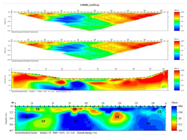
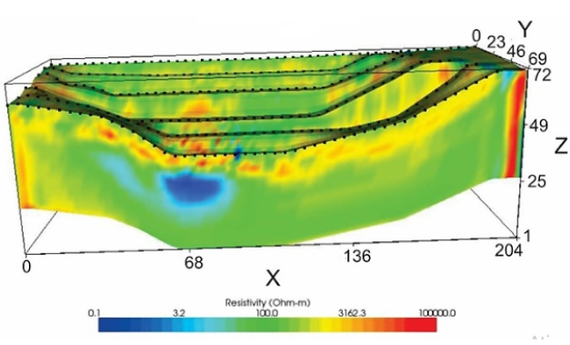
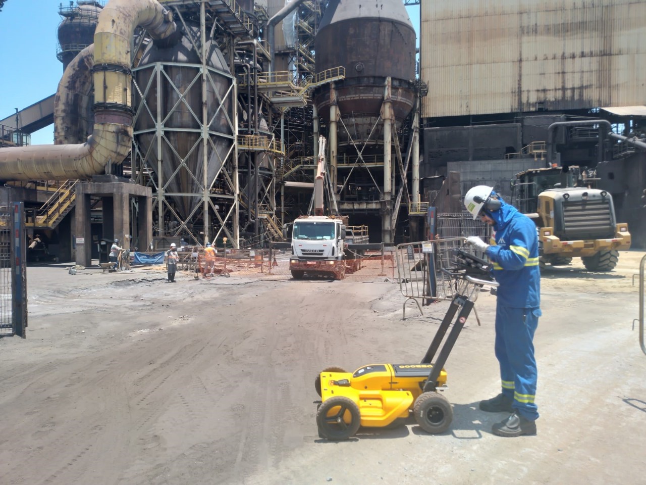
Electrical Resistivity involves the controlled injection of an electric current into the ground using electrodes, allowing the measurement of electrical resistivity in different regions of the subsoil. This data reveals crucial information about geological characteristics, such as alterations, fracturing, saturation and geological structure.
By combining information from different sections, it is possible to create a three-dimensional model that provides a complete visualization of the site’s subsoil.
Electrical Tomography:
An advanced variant of electrical walking, Electrical Tomography is known for its automation, programmability and the ability to provide high-resolution results in 1D, 2D and 3D formats.
Every detail of your property matters
Shall we talk? Tell us about your project challenges!
We work with innovative technologies, guaranteeing the delivery of the perfect solution to meet your needs with excellence.
Quality
We value the quality of each of our services.
Responsibility
We are known for meeting agreed deadlines.
Innovation
We have state-of-the-art technology to carry out each service with the utmost precision and detail.
Our work
Our solutions are designed to serve a wide range of sectors.
Industry
Infrastructure
Mining
Oil and Gas
Industry
At Mirante we apply the most advanced technologies in the search for the best results. Find out more about our services and how they can help industry operations.
At Mirante we apply the most advanced technologies in search of the best results. Find out more about our services and how they can help your infrastructure operations.
Mirante’s surveying services are the primary support for several mines in operation. We work to ensure that daily activities, whether OPEX or CAPEX, are technically feasible and carried out optimally. At Mirante we apply the most advanced technologies in the search for the best results.
At Mirante we apply the most advanced technologies in the search for the best results. Find out more about our services and how they can help your oil and gas operations.
Send us your message and we'll get back to you shortly
Saiba mais sobre a
Mirante Engenharia
Institucional
Conheça nossos serviços
Serviços
Não perca nossos conteúdos
Conteúdos
Pesquise neste site
Find out more about
Mirante Engenharia
Institutional
Find out more about our services
Services
Don't miss out on our content
Contents
Search this site
Contact us
Contact
Find out which areas we work in
Performance
This site is registered on wpml.org as a development site. Switch to a production site key to remove this banner.
We use cookies to ensure that we give you the best experience on our website. If you continue to use this site we will assume that you are satisfied with it.OkPolítica de privacidade